Core Principles
Accuracy
Earthwork Services operators manually make sure that every high and low elevation
point, ridge, swale, break line, hinge, top/bottom of wall and pad elevation is
accounted for in our digital terrain model and is considered in the volumes calculations.
Fast Turnaround
Most projects are in and out of our shop within 48 hours after
we receive the plans and CAD files. In some instances we can even provide same
day turnaround. All volumes are emailed as a PDF as soon as they are available.
Cost
Most residential and commercial projects cost between $85-$500 (on average
$300). The price includes a complete set of graphics, volumes,
areas, a summary letter and area label map.
Services
 We are experts at creating 3D computer models that can be used for:
- Calculating Earthwork Volumes for:
- Subdivisions - Single Family - Multi Family
- Commercial Sites - Large Business Parks to Single commercial Buildings
- Planned Communities
- Schools
- Single Residences
- Golf Courses
- Goverment projects
- Highways
- Cross sections
- Parks and Trails
- Water Treatment sites
- Sports complexes
- Underground Structures
- industrial Sites
- etc.
- Flood Plane analysis
- Conceptual Design
- 3D Graphics
- 3D Animated Drive Throughs
- GPS - Machine Control
- Expert Witness
Earthwork Volumes
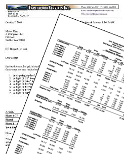
From your design you can receive the following information, which can be utilized in negotiating bids, settling engineering issues and verifying cost estimates.
We customarily address the following items in our Earthwork Volumes.
- Stripping
- Demolition
- Strata Layers (such as rock)
- Over-excavation and Back Fill
- Pre-Load
- Structural Fill
- Phasing / Staging
- Sub-Grades
- Compaction
- Balance Analysis
We can calculate volumes from hardcopy, electronic or hand drawn grading plans. We can build your grading plan from road centerline horizontal and vertical alignment and typical sections. We also have the ability to calculate volumes from plotted cross sections.
Volumes are sub-categorized and broken out for building pads, paving surfaces, ponds, and general landscaping to define varying material types such as structural and non structural fills. They can also be customized as per your directions to meet your specific needs.
Graphics
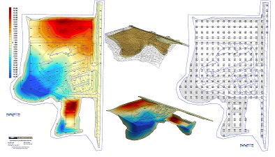
Our reports can come with either booklet (8 1/2" X 11") or Poster size (24" X 36" or larger) graphics.
Our typical package includes:
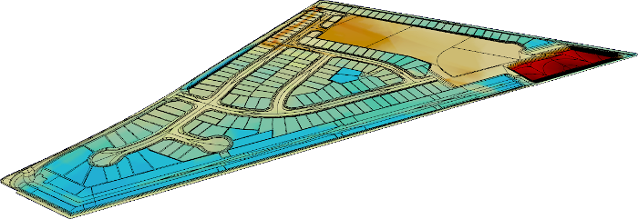
- Color Shaded cut/fill depth map in plan view
- Cut/fill Elevation grid map in plan view
- 3-D views of the existing and design surfaces
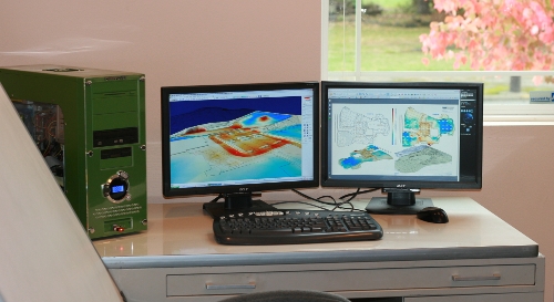
GPS Models
Our years of experience building accurate digital terrain models makes
the difference for you in dollars and time. We are an authorized model
provider for Trimble and Terra model systems. We can create digital Terrain
Models for Trimble grading control equipment created in Terra Model or in
Agtek 3-D, AutoDesk Civil 3-D, and Advanced TIN Master DTM for use in most
industry standard GPS machine control equipment such as Topcon, and Agtek.
Now available from AGTEK - Smart Dirt app (works with Android phones, tablets and iPhones)
You can attend pre-bid walk-thrus armed with the plan set in your pocket; geo-locate pad corners, grading limits and daylight lines; mark spoil piles; and initiate your takeoff on-site using SmartDirt’s measure mode. Email reports back to the office or save them to the cloud.
http://www.agtek.com/smartdirt.asp
Expert Witness
We have extensive knowledge in earthwork and civil engineering software, earthwork calculation methods, as well as surveying, grading design, and earthwork construction. We are able to successfully defend our own calculations, and challenge opposing computer generated earthwork calculations.
We can analyze and often correct insufficient or bad data, inaccurate Tin models and quantity computations. We can prepare or challenge evidence, and provide expert witness testimony. We can show what went wrong, and be able to document and display findings, and provide resolution to most earthwork disputes.
We are comfortable both in meetings and courtrooms. Over the years, we have made, or in some cases saved, our clients millions of dollars in resolving earthwork related disputes.